By Kaitlin Hoskins, New Editor
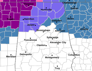
A threat of widespread winter weather across Alabama is possible, though the threat has diminished in recent days, but residents in Etowah County and much of North Alabama should remain cautious as freezing rain, icy roads and cold temperatures are expected from Friday night through early next week.
According to Alabama Emergency Management Agency meteorologist Jim Stefkovich, the approaching system will bring mostly rain for much of the state, but ice remains a concern for northern areas, particularly late Sunday and into Monday.
“For most of Alabama this will be simply a big rain event,” Stefkovich said. “The greatest risk of ice accumulation from freezing rain will be over the northwest and northeast corners of the state, but black ice could be an issue for the entire northern half of Alabama Sunday night and Monday as temperatures fall rapidly.”
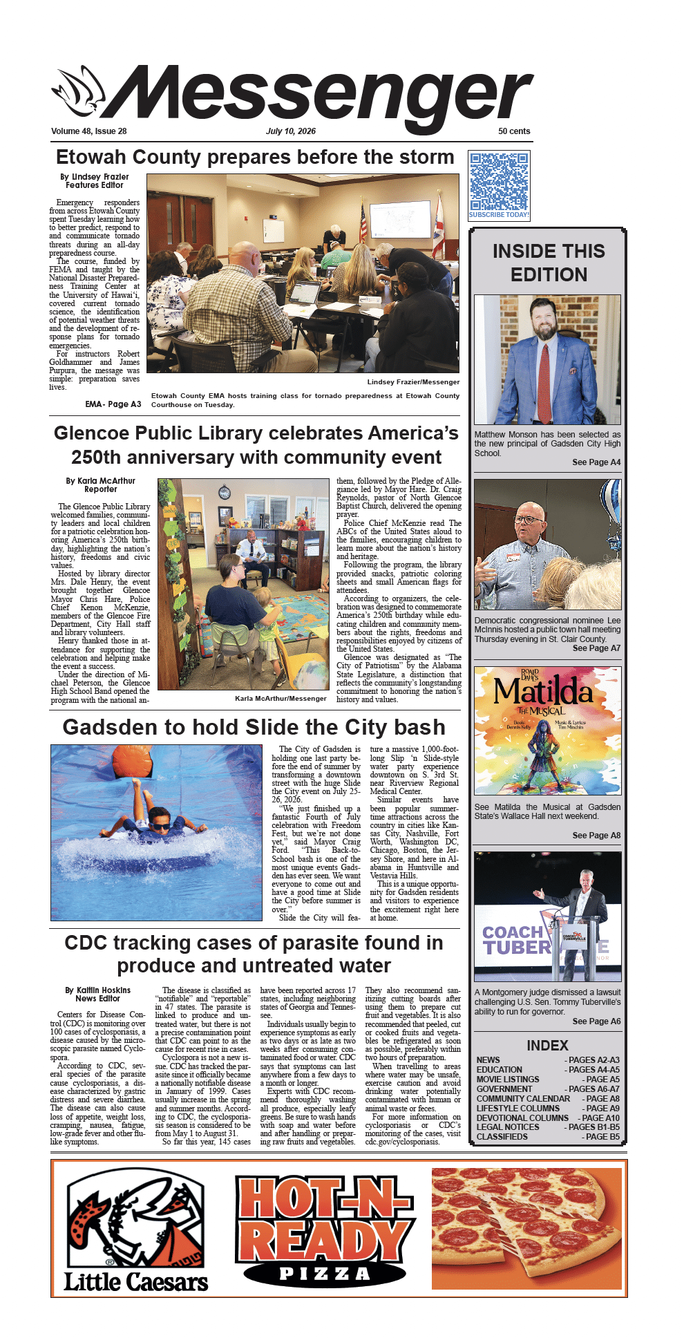
A Winter Storm Watch is in effect for areas north of Interstate 20 from 6 p.m. Friday through 6 p.m. Sunday.
Timeline and Expected Impacts
Scattered rain showers are expected to continue across Alabama through Thursday afternoon before tapering off. Precipitation is forecast to redevelop in northwestern Alabama early Saturday morning and spread across the northern half of the state during the day, becoming widespread Saturday night into Sunday. Rain is expected to end Sunday evening.
Forecasters predict 1 to 3 inches of rainfall across northern Alabama, with lesser amounts farther south.
“This is a very close call of rain versus freezing rain, and it could change,” he said.
For Etowah County and surrounding northeast Alabama, a cold air damming pattern could increase icing potential late Saturday or Saturday night. A brief warm-up with cold rain is possible Sunday morning, followed by a rapid temperature drop later in the day.
“Icy travel is possible Sunday afternoon through Monday morning due to any freezing rain accumulation and the potential for black ice or a flash freeze,” Stefkovich said.
Ice accumulation across North Alabama is expected to be generally one-tenth of an inch or less, though isolated higher totals remain possible in the far northwest and northeast. Isolated power outages could occur in areas that experience repeated icing.
While a few snowflakes may be seen Sunday afternoon as colder air moves in, significant snow accumulation appears unlikely.
Temperatures will plunge behind the system. By Monday morning, lows are forecast to fall into the teens across North Alabama and the 20s elsewhere, with highs Monday remaining in the 20s and 30s in northern areas. Single-digit temperatures are possible early Tuesday morning, potentially making it the coldest morning of the season.
Safety and Preparedness
Emergency officials urge residents to take precautions to protect themselves, their homes and their families during the prolonged cold spell.
Cold exposure: Prolonged exposure to cold temperatures can lead to hypothermia or frostbite. Residents should limit time outdoors, dress in multiple layers, cover exposed skin, and bring pets indoors. Those without adequate heat should seek warming centers or stay with friends or family if possible.
Home heating safety: If power outages occur, residents should use only approved heating sources. Never use ovens, grills, camp stoves or propane heaters designed for outdoor use inside homes or garages, as they can produce deadly carbon monoxide. Fireplaces and wood-burning stoves should be used with proper ventilation, and space heaters should be kept at least three feet away from flammable materials and turned off before sleeping.
Carbon monoxide awareness: Ensure carbon monoxide detectors are working and have fresh batteries, especially when using fireplaces or fuel-burning heaters.
Pipe protection: To reduce the risk of frozen or burst pipes, residents should wrap exposed pipes, especially those in unheated areas such as crawl spaces or garages. Let faucets drip slowly during the coldest periods, open cabinet doors under sinks to allow warmer air to circulate, and know how to shut off the main water supply in case a pipe bursts.
Travel safety: Drivers should avoid unnecessary travel during freezing conditions and remain alert for black ice, particularly on bridges, overpasses and shaded roads. Keep an emergency kit in vehicles that includes blankets, water and a flashlight.
Check on others: Residents are encouraged to check on elderly neighbors, those living alone, and anyone with medical or heating needs during the cold snap.
The Etowah County Emergency Management Agency will continue to monitor the situation and provide updates as conditions evolve. The latest forecasts and alerts are available at www.weather.gov/bmx
Questions may be directed to the Etowah County EMA at ema@etowahcounty.org
Because the forecast involves several variables, officials stress that conditions could change and encourage residents to stay informed as the weekend approaches.