Etowah County could see some strong severe thunderstorms and possible tornadoes Saturday afternoon into Saturday evening.

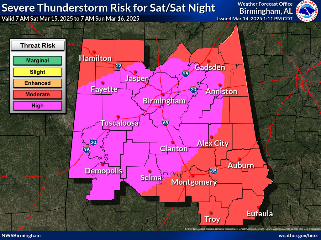
The National Weather Service Storm Prediction Center has now upgraded some of Alabama to a level five out of five “high” threat risk, but Etowah County is just outside that risk area and is instead still in a level four out five “moderate” risk. Counties to the south and west of Etowah County are within the highest risk level, but all areas of the state are at risk of significant severe weather, including damaging straight line wind up to 70 MPH, up to golf ball sized hail and tornadoes.
Some tornadoes could be strong (EF-3 or higher) and long tracking (on the ground for several miles, typically longer than 25 miles).
According to meteorologist with the Birmingham forecast office of the National Weather Service based out of Calera, confidence continues to grow that the state will see a significant outbreak of severe weather. Data available on Friday afternoon indicated there will be two rounds of storms on Saturday, March 15.
The first round of storms will come overnight Friday night into Saturday morning. That storm round will be less severe than the secondary round, but forecasters say residents should still heed any warnings issued. The second round of storms is predicted to begin to fire off after 12 p.m. noon for Etowah County.

Forecasters are urging anyone in the path of the storms to heed any warnings issued. If a tornado warning is issued for one’s location, they are urged to take shelter immediately, on the lowest level in a site-built building, away from windows. It is recommended that people shelter in a small room (like a bathroom or closet) in the center of the building. Basements and underground storm shelters are preferred, but if none are available, residents are urged to place as many walls between themselves and the outside wall of the building as possible.
It is also recommended that everyone wear a helmet (bicycle, motorcycle, football or baseball helmet) to prevent blunt-force trauma to their heads and it is recommended that everyone wear hard shoes in case they have to walk across storm debris. A portable airhorn is also recommended.
If one finds themselves driving when a warning is issued, they are urged to find a sturdy shelter. Attempting to outrun a tornado is not advised. Do not drive over fallen power cables or other storm debris.
Any person living in a mobile home or an RV are strongly advised to seek shelter elsewhere ahead of the storms. If a tornado watch is issued for Etowah County, county operated storm shelters and safer locations will open. To find an open shelter, visit ShelterEtowah.com.
Residents and business owners are strongly encouraged to have a properly programed and functioning (plugged in and with fresh batteries installed) all-hazard NOAA weather radio inside their homes or businesses. Weather radios have backup batteries and will alert to storm warnings even if power is lost to the building. If a NOAA weather radio is not available, individuals are advised to enable Wireless Emergency Alerts (WEA) on their cellphones. These alerts will emit a loud noise and a pop-up will display on the phone’s screen to describe the storm warning. When WEA is enabled, phone users also receive Amber Alerts and other emergency alerts.
Residents are discouraged from relying on tornado sirens, as they are less effective and unreliable.
Tune into local media coverage of the storms through social media, television or radio. Individuals are advised to find a reliable source of information and discuss their safety plan ahead of the storms Saturday.
For more information on being prepared for severe weather, visit GECEMA.com.
This article was last updated at 3:30 p.m. CST, Friday, March 14, 2025.